The Explorers woke up early once again, anticipating their last full day of travel. They fired up the generator (hopefully for the last time before they can troubleshoot the radiator problem) and made breakfast. Captain Mark pulled up the anchor and noticed two main differences in Lake Champlain compared to the rivers and canals he had traveled. First, the anchor came up covered in seaweed, and second, he was amazed that he could actually see the anchor line under the water, indicating that this is the cleanest, clearest (and probably coldest) water he has encountered since leaving South Carolina.
When the Explorers left the anchorage, it was foggy and chilly. The tail of Lake Champlain gradually widened until it was an expansive lake. The water stayed as smooth as glass until they got closer to the northern end of the lake. Because the water was so calm, the autopilot was doing most of the work all day, needing very little adjustment to the heading. Over time, the sun came out and the air warmed up.
When he reached the northern edge of the lake near Plattsburgh, Captain Mark buzzed by the Dixon Camp on shore as he called to see if anyone was there. Cousin Joey had just arrived, and Cousin Robert and his wife Dana, were just heading over to the Plattsburgh Boat Basin themselves to grab their boat and take it out for a little ride. They share a boat with Robert’s sister Elaine and her husband, Steve, which is in the same marina where the Wayward Explorers are ending this adventure.
The Explorers waved to their cousins and turned around to cross the bay to the marina. They parked at the fuel dock to “check in” and were directed to their slip, their home for the summer. They made it into their slip with a little “help” from a marina dock hand, although they agreed that they might have managed the landing a little better on their own, as the dock hand seemed a little inexperienced at handling the lines. The marina appeared to be half-empty as much of the clientele is from Canada and the border is still closed. Many boats, hailing from Canadian towns, were still up on stands around the marina.
Once settled, the Explorers got out their folding bicycles to head over to the Dixon camp. They visited with Joey and then they all headed out to McSweeneys to get some world-famous (at least North-Country famous) hot dogs with Michigan sauce. On the way home, they grabbed some beer to celebrate. Back at camp, they were joined by Robert and Dana, back from their boat trip, and enjoyed catching up over their celebratory beers. A few next-generation Dixons buzzed in and out of camp to jet ski and visit. After a few hours, the Explorers needed to bike back to the marina before it started to get dark and they ended the day with a walk into downtown Plattsburgh to get the “lay of the land” and earn their Fitbit points.
And so, this journey is complete, from Little River, SC to Plattsburgh NY. The next week will be spent getting to Massena to retrieve the motorcycle that was left there (when the Explorers thought that was their final destination), stopping home in Lincoln, NH to gather piles of mail and getting to Philly to pick up their Jeep that was generously delivered to their son’s (Mike’s) house by Sidekick Sue’s sister and her husband. The Explorers will be splitting time between Plattsburgh, Massena and Lincoln, NH throughout the summer and encourage any family or friends that are nearby to reach out to set up a visit. See you at the Naked Turtle. Cheers!
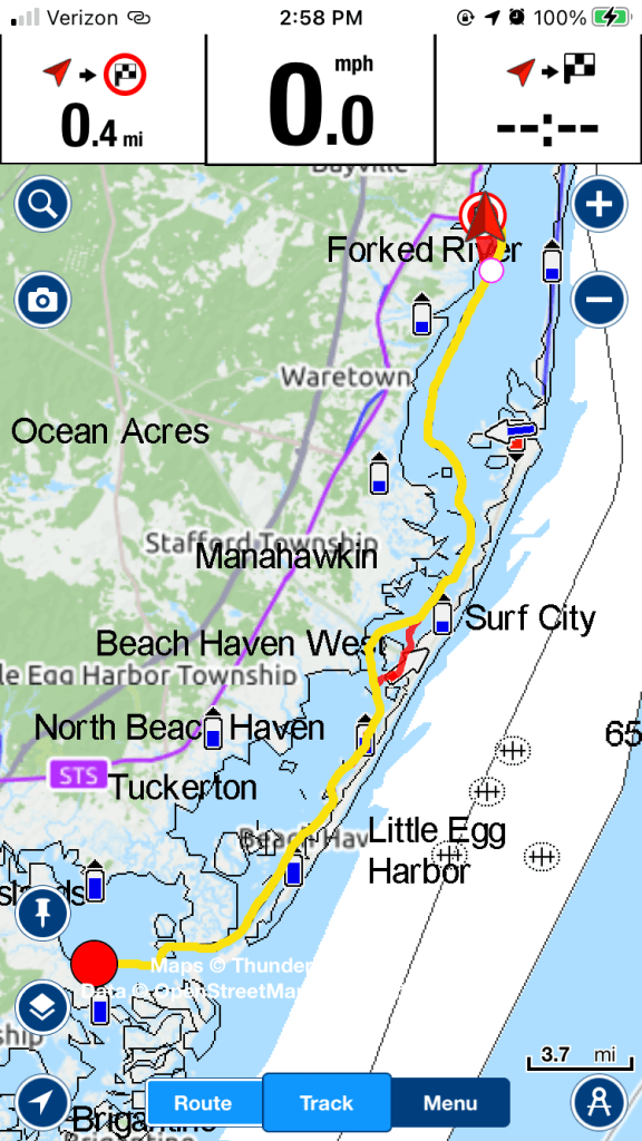
The route for the final day.View from Lake ChamplainMore sights from the LakePassed a light house on shore.Our new home. Happy to be out near the end of the dock (even if somewhat isolated) because it will be easier (and deeper water) to get in and out. The Wayward Explorer in her new home.The Wayward Explorer from a bike path we found.
Morning came early for the Explorers, as much as they tried to sleep in. The original plan was to take three more travel days to get from Fort Ann to Plattsburgh. Over beers last night, the Explorers had discussed splitting the distance between two days and arriving on a Saturday instead of a Sunday, which might better afford the opportunity to see some of the cousins (like Joey), that were coming up for the weekend. The mileage was manageable, but would mean more motoring and less stopping. In the morning, the Captain decided to go with the two-day plan, meaning the Explorers had to be out of the Champlain Canal and partway up Lake Champlain by the end of the day.
The Explorers left their free dock in Fort Ann and immediately passed through Lock #11 which lowered their boat 12’. If you’re counting, you may have noticed this story skips Lock #10, as it turns out there is no Lock #10. The Explorers asked the locktender at Lock #11 (who had been working the locks for 29 years), and it turns out that there were plans for a Lock #10 that never materialized, and apparently the NYS government (in its infinite wisdom) never bothered to rename the others.
Right before Lock #12 (the last one), the Explorers stopped in Whitehall, NY. It’s another small NY town that has built a wonderful Museum and Visitor’s Center to welcome those coming by water and by land. Captain Mark and Sidekick Sue recalled stopping here once before when driving to Saratoga Springs. Whitehall claims the distinction as being the “Birthplace of the U.S. Navy” and they have many historical items on display, as well as an outside display of the remains of the USS Ticonderoga. Sidekick Sue didn’t recall (from the first visit) that it was right on a canal, and probably never imagined that she would be returning there by waterway just a few years later.
The Explorers took advantage of the free electricity on the free wall and made breakfast. Then, they went out and walked a big loop around Whitefield, first exploring one side, and then crossing over to the other side of the canal. Along the way, Sidekick Sue ventured into Carol’s Collectibles and found some turkey salt and pepper shakers to add to the Thanksgiving collection. The store is fabulous for treasure hunters, with 12,000 square feet of items priced to move. It is also home to “CC the Cat”, an adorable stray that found a home at the store. Sidekick Sue talked to Carol herself. When Sidekick Sue mentioned they were walking around town, Carol immediately asked if they “came by boat”, as it appears many of her customers do. When asked if there were more Thanksgiving items around, Sidekick Sue was disappointed to learn that a 2020 flood had destroyed most of Carol’s seasonal inventory that had been in storage. Carol said that she and CC were taken out of the store in a rowboat by the fire department. Thankfully, she was able to rebuild and reopen this adorable business after a tough year of Covid and flooding.
Up on the hill above the canal sits a very distinctive landmark, Skene Manor, a beautifully restored Victorian Gothic -style mansion. The Explorers would like to return to Whitehall again to visit this historic site, but since they had increased their boating mileage for the day, they needed to “hit the waterway”.
Right after the Whitehall Visitor’s Center was Lock #12 (which lowered the boat 15.5’), the LAST lock in the sequence. Sidekick Sue was glad to be through the locks and they were now officially in the tail of Lake Champlain, the last obstacle between the Explorers and the Plattsburgh Boat Basin. The first ten miles of Lake Champlain was very narrow and winding; the shores alternated between swampy and sheer rock cliffs. We passed Fort Ticonderoga, located at the top of one of a hill along the canal. After a while, the Lake slowly widened and Captain Mark was able to resume use of the autopilot, which is much more useful for open water crossings than it is for navigating the narrow canals. After a few more hours of motoring, they reached their anchorage at Button Bay, home to Button Bay State Park in Vermont. After a quick dinner, Captain Mark went to work raising the mast again, because the Explorers needed to be able to display their anchor light for the night, and they are done with the low clearance bridges through the canal. By the time that chore was done, Captain Mark was tired and it was getting too dark to row to shore to explore the park. Unfortunately, the Explorers would be short-changing the Fitbit Gods tonight, but it was a minor trade-off, given that they would arrive in Plattsburgh a day earlier. It was a quiet night, with Captain Mark retiring to read, and Sidekick Sue starting to sort the pieces of another jigsaw.
Route today. Inside Lock #11Looking backwards back at Lock #11. To the left, you can see the dam which demonstrates how the distance the lock had to lower us to get to the new water level.Free wall in Whitehall. View is from the bridge we crossed on our walk.Skene Manor up on the hill above the canal.The rocky ledges along the tail end of Lake Champlain.Fort Ticonderoga up on the hill.
Last night, the Explorers had decided, on the spur of the moment to get up extra early to “see” the eclipse. Of course, they had no proper equipment and hadn’t prepared in any manner, but nevertheless, they got up at 5:30 to go outside and look around. Sidekick Sue lingered in bed a little longer, but finally resolved to getting out of bed, to find Captain Mark in front of the Waterford Visitor Center trying to look at the sun without looking at the sun. Captain Mark swore he could see the crescent if he looked really fast at the sun from side to side. Sidekick Sue just saw a big blob. They have vowed to be more prepared, when the Great American Total Eclipse sweeps across northern NY (Buffalo, Rochester, Watertown) on April 8, 2024. (Note to Sidekick Sue…. buy the special glasses now, when no one else is thinking about it).
Today was a day of going through locks on the Champlain Canal. The Explorers left right after the “eclipse viewing” and made it to the “Lock #1” just as it opened for the day. The first lock raised the boat 14’ , and Lock #2 raised the boat another 18.5’. The Explorers are finding they are nearly all by themselves on the Champlain Canal. It seems that everyone else took a left at the Erie Canal. This means that they are in the locks by themselves and they have a choice of where to park. For the first couple locks, they were parking with the port side of the boat to the wall. Sidekick Sue handles the lines to keep close to the wall, while Captain Mark hits the bow thruster every so often to make sure the front rails don’t hit the wall. The Explorers agree that they need to add a couple of big round fenders to the front of the boat to fend off the cement bulkheads and locks they have encountered on this trip.
Between Locks #2 and #3, the Explorers stopped at a park with a cement bulkhead provided by the city of Mechanicville. The amenities even included free electricity, so there was no need to fire up the struggling generator (still need to find the hole in the radiator) to make breakfast. They took a quick walk through Mechanicville, and found that there was not much to see. It appeared to be another “burned out” industrial upstate NY town with few signs of prosperity. Surely, these towns saw better days when the canals were bustling with commercial activity. A brief miscommunication (and small spat) during docking led the Explorers to realize that it made much more sense to be on the same side of the boat whenever possible giving the Captain a better view of what the lineperson was doing, and making communication easier. Of course, this is not always possible when docking, but the Explorers resolved to approach the lock walls on the starboard side, whenever possible, moving forward.
The rest of the day was spent negotiating the locks. Each successive lock continued to raise the Wayward Explorer as it passed through Lock #3 (25.5’), Lock #4 (10’), Lock #5 (19’) and Lock #6 (16.5′). Depending on whether the lock was already occupied with a south-moving vessel (only happened once), or if it had to be emptied before we could approach (happened several times), each lock could take up to a half-hour to get through, so travel time was longer than expected. As it turned out, rising early to see the eclipse was an important factor in getting to the planned destination before the locks closed for the day. The Explorers had wanted to stop at Fort Edwards to do some more walking, but decided to stay the course because of all the time that had been lost to lock-throughs. Up until Fort Edwards, the Champlain Canal was fairly wide and winding compared to the other man-made canals, as it was still connecting vestiges of the Hudson River. After Fort Edwards, the Hudson River veered away, so the waterway was a narrower, man-made trench.
Lock #7 raised the Wayward Explorer another 10’ and Lock #8, another 11’, for a total of nearly 125’ for the day. The Explorers were getting pretty good at managing the locks by this point, even getting pretty tired of them. As the Explorers approached the final lock for the day (Lock #9), they were surprised to see the walls were so low. That is when they realized that this lock was already full of water and was going to be taking them down 16’.
The Explorers reached their destination in Fort Ann right around dinner time. Fort Ann provided a small free, floating dock, but without any amenities, so the Explorers had to crank up the generator to make pizza. After dinner, they walked around Fort Ann, which (didn’t take long), and then walked a mile or so up the Champlain Canalway Trail a mile and back to finish up their “steps” for the day. On the way home, they stopped at the Battle Hill Brewery to have a few draft beers. They were entertained by a little boy at the next table over who was putting on a show for them to get their attention while his parents obliviously ate their dinners. The Explorers retired back to the boat in the park; it was too buggy to sit outside and enjoy the night air. It was a quiet early night, as they were hoping to get extra sleep to make up for the early morning.
Today’s route.Entering Lock #1.The sign at Champlain Lock #1 and the dam next to the lock in the background.Bald Eagle on the shore right after the first lock.On the free wall in MechanicvilleInside another lock as the water fills up.Passed under this gate. We don’t know the circumstances of when they would use something like this, or what a boater would do if it was in the “down” position?Sign at Lock #7Lineperson taking good care of her lines. A building that has seen better days.The dock that we used overnight at Fort Ann. Not the most impressive dock, but it was free. The Captain drinking a chocolate porter.The little kid that entertained us while we were having beers.
The Explorers left their overnight accommodation on the “no overnight” dock in Athens. As they traveled north toward Albany, the Hudson River became more industrial. They passed downtown Albany on their port side, the familiar capitol building visible from the waterway. Instead of trees, a highway now paralleled the river. Shortly before reaching their destination of Waterford, they approached through their first lock, (Troy Federal lock #1) in the NYS canal system. They had radioed ahead and were just waiting for the lock doors to open and the green light. There was already a boat tied to the dolphins before the lock. As Captain Mark idled up close to him, he suggested they go in first since he had just been waiting, trying to figure out if the lock had a set schedule or if he was supposed to do anything. They all entered the dock, went up several feet and moved through when the exit doors were opened.
From this point on, the Explorers no longer had to worry about tides and tidal currents from the ocean, because the locks control the water height and prevent the tidal current from flowing north. Just up ahead, they reached the spot where the waterway splits depending if boaters want to enter the Erie Canal or the Champlain Canal. Had their original plans not been disrupted, this is where they would be turning left to start up the Erie Canal, starting with the “flight of five” locks that are spaced very closely at the beginning of the canal. Instead, they will be following the Champlain Canal up to Lake Champlain and Plattsburgh. However, the Waterford Town dock was their destination for the night, so they turned left toward the Erie Canal locks.
The Waterford Town Dock has a reputation for being a great free dock with almost all the amenities of a paid marina. It shares space with the Town Visitors’ Center and has free showers and water with only a minimal fee for pump-out service and electricity. It is close to town and only a short walk to a laundromat and Hannafords. Boaters can stay for 48 hours, so the Explorers planned to stay for two nights to take care of laundry and shopping. There are two different docking areas. One is a wooden floating dock and the other is a tall cement bulkhead. The preferred place to dock is the wooden dock, where you can easily step off your boat. Unfortunately, it was full, so the Explorers were stuck on the bulkhead (at least for the first night). The boat that they had helped get into the lock pulled in behind them so they went down to talk to him. The first thing he asked was “How long is the line?”. The Explorers weren’t sure what he was talking about, until they realized that he thought everyone tied up in Waterford was waiting for the first of the “flight of five” locks to open. He was planning on pushing on toward Buffalo that day; he had picked up a boat in Long Island, and had clearly not done any research on the route or learned how to use his radio. The Explorers explained to him that the people docked were likely staying for the night, and gave him instructions on how to move up ahead toward the lock, radio them, and request an opening. They wished him well, watched him pull up, and within about 15 minutes, the lock opened, so they assumed the Buffalo-bound man had figured it out; although he still had four more locks to get through before they closed at 5:00 for the day. The Explorers thought it was funny to think that amateurs like themselves were now giving advice to other boaters .
On the bulkhead, there are occasional ladders built into the wall, but without a ladder, one must climb up onto the boat railings to get onto the bulkhead. The Explorers were lucky enough to have a spot with a ladder, but as more boats came in and the wall was filling up, they felt too guilty to leave a half a boat length empty in front of them, just so they could line up with the ladder. So, they manually pulled their boat forward, even though it meant giving up the ladder. In the end, they knew they had made the right decision when a small boat docked behind them, so short against the wall, that the occupant would never have been able to climb the wall without the ladder. What was a slight inconvenience for the Explorers was a blessing for the next guy.
Once settled on the bulkhead, the Explorers realized that access to water and electricity was only for folks on the wooden dock. They had been hoping for water because they hadn’t been able to spray down their decks in a while and had been accumulating a lot of mud (from the anchor), bugs and random debris. They went up to the Visitors Center to check in and get a key for the restrooms. Captain Mark did his best to do some outside cleaning using a bucket, lowered into the canal for water, and Sidekick Sue focused on the inside because they were hoping to see some friends over the next few days and piles of clutter had started to accumulate. The weather was hot and humid, but they did their best to push through the chores and rewarded themselves with a real shower.
The Explorer’s first visitors were Rena and Doug, some friends from college. They had contacted the Explorers a few weeks into the trip and offered to stop by the Waterford docks to visit and/or help with any errands. They live nearby and are familiar with the neighborhood, so they were able to suggest a few great breweries. After a quick tour of the boat (complete with techniques for climbing up and sliding down the bulkhead), the foursome ended up going to Druthers, in Albany. Druthers was a great place for beer, food and friends. There was a lot of catching up for friends who haven’t seen each other in a couple of years, and a lot of talk about retirement plans (who would have ever thought for friends that met at the start of their careers?). Captain Mark and Sidekick Sue both indulged in Druthers famous macaroni and cheese that was “to die for”, and happily took the leftovers home for the next day. Before dropping the Explorers back at the boat, Rena and Doug were nice enough to drive them all over Albany on a tour, sharing a lot of knowledge about the area. Captain Mark was actually born in Albany, but left as a youngster, and neither Explorer has spent much time in Albany “proper”. Most of their visits to the area have been to Schenectady, Rotterdam or Scotia.
It was raining when the Explorers got back from dinner. The bulkhead wall was wet and the Explorers got soaked sitting down on the wall to slide back into their boat. It was a warm rain, and they stayed outside talking to their neighbors towards the bow, who were out enjoying some time on the covered deck, until the mosquitoes came out and forced a quick exit. And so the Explorers spent the first night on the bulkhead in Waterford.
In the morning, the Explorers woke up to the sound of people moving. They figured that those who were leaving to move down the Erie Canal or the Champlain Canal were probably getting started, and folks on the wall were looking for space at the dock. They figured they might have lost their opportunity to sneak onto the dock, however , Captain Mark found that there was still one space on the dock, so they cast off and moved up into the empty space. They were disappointed to find that there was no nearby electric pedestal, but were still grateful that they would be able to get on and off the boat without climbing over their railings. Sidekick Sue walked down to the end of the dock to see if there were openings, but found none. On the way back, she stopped to chat with some other folks that seemed to be discussing solutions to the electricity situation. There was one guy who was parked in front of a power pedestal but he couldn’t use it because he had the wrong cord. However, the graciously offered to move his boat back several feet to see if the Wayward Explorer would fit in front of him and have access to the pedestal. Next thing you know, it became a “community project” to squeeze the Explorers in at the dock. Boat people seem to be extremely helpful to each other. Another boater moved his boat back to provide even more space. The Explorers squeezed in at the dock, only to find their power cord didn’t reach the pedestal. Before you know it, everyone was bringing out their spare cables and connectors to try to get them power. As it turned out, Captain Mark searched through some bins on the Wayward Explorer and found that he actually had an extension cord and an adapter that for their boat, so not only did the Explorers get connected to power, but the guy with the wrong cable was lent the cable he needed so everyone could get power without running generators for the day. The boats were a little tightly packed on the dock, so Sidekick Sue wanted to make sure they weren’t interfering with anyone’s plans to leave, but it appeared that no one was in a hurry to go anywhere, and it was likely that the Wayward Explorer would be the first boat out in the morning. Again, the Explorers learned that they have a lot to learn about “taking it easy” and “not thinking too far ahead”. Maybe one day, they’ll get the hang of cruising life.
Captain Mark went out exploring on his bike and rode a few miles on the Champlain Canalway Trail while Sidekick Sue started sorting laundry (and decided to rearrange her clothes cabinet space to accommodate the fresh laundry that would have to fit in there later that day).
The second visitors to Waterford were Sidekick Sue’s college roommate Shirley and her husband Van (who was also at Clarkson). Shirley and Van are experienced sailors, and they had been following this blog, and knew that the Explorers were getting close to Van’s family camp. Shirley contacted them and asked if they could come visit for lunch on their way to drop off some items at the camp… and of course the Explorers (always hungry) readily agreed. Shirley put together a wonderful picnic, complete with tuna pitas, fruit, chips and cookies. Having read about the struggles the Explorers have had, carrying seltzer water in backpacks and on bikes, she arrived with several cases of Schweppes seltzers. They enjoyed a wonderful picnic in an area overlooking the first lock on the Erie Canal that Captain Mark had scoped out. The foursome had wonderful conversation and made plans to stay in touch as Shirley and Van are planning an awesome camping adventure of their own, and there might be an opportunity to overlap in San Diego next winter. Shirl had one last surprise, a “happy hour” flag to raise for those special times on the boat and after many hugs, they headed off to run their errand at camp.
Sidekick Sue and Captain Mark lugged the laundry into town. For once, the laundromat was only a few tenths of a mile away. They tried to get some Fitbit steps in during the wash cycle, and more during the drying cycle, and lugged the laundry back to the boat. Captain Mark walked to the grocery store to pick up a few small things while Sidekick Sue finished another jigsaw puzzle.
The evening was rounded out by a third visitor for our first official “Happy Hour”. Captain Mark had let a few cousins from the Schenectady area know that he was in Albany and we’d be around for the evening . Cousin Joey answered the call and came over to share a wonderful evening on the fly bridge. We’re looking forward to seeing Joey and all the Dixon cousins this summer, as they all spend time in Plattsburgh at the old Dixon camp.
The day’s route.The Albany skyline.The Troy Federal Lock #1The dam next to the Troy Lock.A very important intersection on the water. Funny, because there aren’t many street signs in boating.A look behind the scenes at Druthers Brewery.The RCA dog on top of the old RCA building in Albany.When we squeezed onto the wooden dock in front of a very helpful boater. The laundromat that thinks it is an ice cream parlor. Sadly, no ice cream. Picture of the Explorers taken by Shirl, who says we don’t put enough pictures of ourselves in the blog. LOL
In the morning, the Explorers had to pull up their very deep anchor. It took Captain Mark a lot of time and effort, but he finally retrieved it. After that experience, Captain Mark is thinking that an electric windlass may be in our future.
We continued our trip north up the Hudson River. The river is lined with hills and trees. Every once in a while, we would see a huge mansion tucked into the hillside. The trains, Amtrak on one side and commercial on the other continued to run back and forth all day. We motored past several of the cutest little lighthouses, built on tiny islands in the middle of the river.
After a few hours we stopped for fuel and a pumpout in Kingston. We had picked Kingston, because our Navionics had indicated that it was the cheapest fuel around, however, when we arrived, we learned that the prices in Navionics are only as accurate as the boaters that update them. The actual price was quite a bit higher, but since we were already there, we got some diesel anyway. We didn’t fill the tanks as planned, acknowledging to ourselves, that we need to find a better way to verify fuel prices in the future.
The inlet into Kingston was about a mile of twisting waterway that hosted an interesting collection of old rusting vessels: tugboats, ferries, and barges as well as an oddly placed pontoon boat, seemingly grounded on a jetty. We found the marina, found the fuel dock and got our diesel, a pump-out and water for our tanks.
As we were finishing up, another trawler, the “Selah Way” pulled up waiting for the fuel dock. They pulled up close enough for us to chat. We must preface this story by explaining that the prior day, when we were motoring along, we suddenly noticed a motorized dinghy, rushing up to us at a high speed, strangely not deviating from a collision course, when it was clear they could see us. Out of caution, Captain Mark, pulled back the throttle to slow down. The dinghy pulled up next to us, the occupants laughing and apologizing because they thought we were someone else, someone that they knew. We didn’t think much of it. Anyway, fast forward to the fuel station, and the people from the Selah Way identified themselves, Steve and Amy, as the crazy dinghy riders who accosted us. We all got a laugh out of it, chatted a little bit, discovered they were also headed to Lake Champlain, so we might see them again.
We left the fuel dock and motored on to the Town of Hudson, where there was a free daytime parking dock. Captain Mark had called the town ahead of time and asked if overnights were allowed and got a resounding “no”, but we were just planning to explore the town. As it turned out the dock was very small, clearly meant for smaller power boats, but Captain Mark decided to attempt a docking anyway (Sidekick Sue was terrified). On his first attempt, he swung a little wide, too close to some folks fishing on the opposite side of the small channel that housed the dock, and he caught one of their fishing lines. He backed up and pulled in again, this time close enough to the dock and Sidekick Sue tied up while Captain Mark went to address his little snafu. He apologized to the owner of the fishing line we had snagged, and donned his swimming gear and snorkel to go under and inspect where the line was caught. Sure enough, it had wrapped around the propeller. He had to cut the line and apologize again, because he could not get the owner back his hook. He spent a half hour diving on the propeller, cutting all the pieces of fishing line off the propeller shaft to prevent future damage.
After that excitement, we walked into town. Hudson was a lot like Nyack, but on steroids. The exceptionally long main street hosted numerous art galleries, antique shops, fancy cafes and spas. It seemed so out of character for a little town on the Hudson. It was a Monday, and most everything was closed, but we did pop into a few interesting stores (mostly to partake in the air conditioning). It seemed impossible that a little town like this could support so many upscale shops, however, we later came to find out that Hudson has a train station and a reputation for interesting art and décor, so folks travel up from NYC to do their shopping. Mystery solved.
When we got back to the boat, we had a job to take care of. Our trawler has a mast and a boom which can hold a sail that is apparently helpful in stabilizing your boat if you make any open ocean crossings (like to the Carribean). We had not used the sail on this trip, but the mast had remained in place. Well, after the upcoming lock in Troy, there are some low clearance bridges, so it was necessary for the Explorers to lower the folding mast before the next day’s journey in order to fit under the bridges. So they set to work, first tying a rope around the mast, and to pull it forward during removal of the forward stays. They then used the rope to gently lower the folding mast, and released the back stays. Mission accomplished.
The Explorers might have tried to stay the night (regardless of the rules), but we thought our oversized boat on Hudson’s undersized dock might call attention to our presence. Instead, we decided to move across the river to Athens, where there was another dock, much more “in scale” for boats our size. This was another “free dock”, but technically, it is posted as “no overnight” docking. Having read the reviews, it seems widely known that that rule is not enforced, and more of a way for the town to keep people from living there or leaving their boats parked there full time. So, we decided to take our chances. If anyone came to kick us out, there was an anchorage about 200 feet away next to an island, so we could easily move.
As Captain Mark approached the dock, someone radioed to him, asking if he was planning on docking there. Tentatively, he responded “Yes”, not sure if he was about to be turned away or welcomed. The radio voice responded “OK, I think there’s room for you”. As we approached, two couples came out on the dock and helped us with our lines, guiding us it a little cut-out spot next to the main dock. Coincidentally, it turned out to be David and Amy from the Selah Way again, accompanied by Paul and Michelle from the Agape, the very folks that David and Amy had mistaken us for the other day. We chatted with them for awhile and asked them if they were staying overnight in spite of the “no overnight docking” sign and they said not to worry; if anyone came, they would simply say they were too drunk to leave. LOL. We talked about free docks, and they seemed to know every single one between here and Lake Champlain. Amy and David were experienced loopers, while Paul and Michelle, were relatively new like us, but they had been crossing paths with Selah Way since Florida and had become fast friends.
They told us that Athens was a cute town, but nothing was open. Wanting to stretch a bit, we decided to check it out for ourselves. We walked up the main corridor and back down the other side. Sidekick Sue noticed Captain Mark looking longingly at a brewery that appeared to be open, so she offered to buy him a beer. Strangely enough, they were greeted by a hostess who let them know they were only open for trivia night, and apparently that didn’t include us, so we moved on, disappointed, because we were really anticipating that cold beer on a hot day. By the power of Google, we found a Stewarts Convenience store that was open to pick up some beer, OJ and a tiny pint of ice cream.
Our new “neighbors” were amazed to see us with groceries and we were happy to be able to share a little local knowledge (directions to Stewarts) that these seasoned travelers did not know. We continued to talk to Amy at length, trying to absorb all the helpful information she was supplying. There is so much in boating that is passed on via word of mouth (aka “local knowledge”) and we are just skimming the surface right now. Like the other couple we had met in Atlantic Highlands, Amy and David have made the full commitment to boating, having sold their family home and opted to live aboard full time. Based on Amy’s suggestion, we have a recommendation for a new Facebook group and now have an app called Nebo where we can track the Selah Way and the Agape (and they can track us) and send messages if we notice we are in the same area. Both of them shared their “boater cards” (like business cards…. I guess we need to have some made up) so that we have their contact information if we have any questions. This is the first time we really found a connection to the network that we suspected was out there. These folks were different from the others we met so far that are just moving from marina to marina… they are foragers like us, using free docks and anchorages and willing to share a wealth of knowledge.
Today’s mapOne of several cute island lighthouses we passed.Another lighthouse.Old ferry boat and tugboats lining the inlet to Kingston.Old rusted crane on an old rusted barge on the inlet to Kingston.Strange parking job of a pontoon boat on a jetty.Town of Hudson, streets quiet on a Monday, nothing opened except a brewery that wouldn’t serve us. LOLSome great restored buildings in Hudson.Our new “looper friends”, the Selah Way (in front) and the Agape. We are parked on another shorter dock that is oriented more to the left of the main dock. No overnight docking signs that we are all ignoring.
We didn’t have to get up as early to leave our anchorage in Nyack, although we decided, once again to delay breakfast to take advantage of the favorable tidal current. With little river boating experience, we have been amazed to learn that the Hudson River is affected by the ocean tides all the way to Albany (where we will encounter a lock). It seems counterintuitive, having always assumed that rivers only flow one way from higher elevation to lower elevation. Every day on the water is a lesson in what we didn’t know we didn’t know.
A few interesting observations while heading north on the Hudson today:
There are very busy train tracks on both sides of the river. To our right, there are Amtrak passenger trains constantly traveling back and forth to NYC. To our left are freight trains carrying shipping containers all day long.
We passed a nuclear plant (Indian Point Energy Center) with three units, built in the ‘50s and ‘60’s. The plant is no longer active, the last unit that was running was decommissioned just a month before we came by.
We passed by West Point Academy which has a beautiful site on the Hudson. It appears to be a beautiful campus with impressive architecture, however Sidekick Sue could not disagree when Captain Mark said it looked similar to a prison…. maybe more like a fortress.
We passed by Bannerman Castle, which was built by Francis Bannerman VI, as a warehouse for his military surplus business. His family was originally from Scotland, and the warehouse was built to look like a Scottish Castle. It has long been abandoned and tours of the island (you can’t go in the castle as it is partially collapsed) are offered through the NYS Office of Parks, Recreation, and Historic Preservation.
The views along the riverbanks have changed to hills and cliffs instead of the flat views along the southern part of our journey.
There are lots of loose logs floating down the Hudson. So now, Captain Mark is having to dodge those, as opposed to the crab pots that he was dodging from South Carolina to Maryland.
We anchored in Poughkeepsie between the Mid-Hudson Bridge and the Walkway over the Hudson, a bicycle and pedestrian friendly bridge. The “anchorage” was very deep, nearly 50’, even though we were only 200’ from shore. We had never anchored in such deep water before and the current anchor rope we had on our chain was not going to be long enough for the 250’ scope that we would need. Captain Mark was prepared and got out a brand-new reel of anchor rope that he had bought before the trip, attached it to the anchor, and let it drop. Unfortunately, shortly after the anchor hit bottom, the rope got terribly knotted (like trying to pull yarn from a skein), so he had to quickly pull the anchor up and Sidekick Sue drove in circles while Captain Mark unknotted his anchor rope. A half hour later, the ordeal was over and the Wayward Explorer was anchored safely in the deep water. The reason the word “anchorage” is in quotes above is because it was not like most of the anchorages we have used. It was not protected at all; it was a very wavy experience until after dark when the recreational boat traffic finally ceased. We also noted that we never really “rotated” in a circle around the anchor. We were pulled directly upstream and then downstream, in a straight line, depending on which way the tide was going, which was different from the normal arc-like pattern we have seen in calmer waters.
While waiting to make sure the anchor had “caught”, we had our late breakfast and planned our next moves. We were parked next to a park that had a boat launch and a dock, but the dock was posted as 15 minute loading/unloading, and we wanted to go walk for a few hours. A sheriff patrol happened by and Captain Mark shouted out to him, asking if we could use the dock for our dinghy for a few hours. He said it was fine, but when we got there, we still pulled our dinghy around the back of the dock where it wouldn’t interfere with all the small boats and jetskis that were coming in and out on the boat ramp.
We walked up the hill into Poughkeepsie to do our walking. Initially, we thought about walking the pedestrian bridge across and back, but the heat was sweltering (93 degrees), and we didn’t know what it would be like up there, with no shelter, so we decided to walk through the city instead. We weren’t disappointed about missing the pedestrian bridge, because we had biked it a few years prior during our biking/camping trip from NH to PA.
Poughkeepsie is a typical old NY industrial town that has seen better days. There is lots of crumbling infrastructure, empty storefronts, graffiti, and abandoned buildings. Another thing that struck us was the trash everywhere; I’m not sure we’ve seen a place looking so littered and uncared for. It definitely didn’t have the fun vibe of the other waterfront towns we have visited so far. The only thing that was really impressive was their old government buildings; huge stone buildings from another era which housed their City Hall, Post Office, and other municipal functions.
Unimpressed by the city and the neighborhoods, but still needing more Fitbit steps, the Explorers decided to trek to the nearest “real grocery store” which was a couple miles away. We weren’t desperate for any particular supplies, but it gave us something to do to get our steps for the day. As the heat of the afternoon got worse, they decided this may have been a poor decision, as it was brutally hot, and the route they had followed had no shade trees and no sidewalks. Google had categorized the route as “mostly flat”, but Sidekick Sue begged to differ. Lots of uphill and zig-zagging across the city to get to the air-conditioned Stop and Shop, which they didn’t want to leave. The walk back was nicer, the sun was starting to go down, and they picked a route down Main Street which was more walker-friendly (although no more inviting or clean). In the end the Explorers walked nearly 7 miles in the heat and were ready to kick-back for the rest of the night. We had one more quick scare when Captain Mark remembered he had tied up the dinghy, but not locked it, so we were hoping to find it still there.
As it turned out, the park was still bustling with activity. There were several large family parties going on, some involving fireworks and a release of sky lanterns. Our dinghy was safe and sound, we figured that the presence of so many people would have deterred any mischief. Our only obstacle was a handful of young girls on the dock that asked us a hundred questions about our boat, told us all about the fish they can caught with their bare hands (and then ripped apart and threw back in the water), and wished us a “romantic ride” as we set off in our dinghy.
Back on the boat, Captain Mark jumped in the water to cool down, while Sidekick Sue choose the on-board shower (people warn against going in the Hudson south of Albany). Sidekick Sue tried to work her jigsaw until it got too dark to reasonably see the colors (our battery powered cabin lights aren’t that bright) while Captain Mark sat up on the flybridge enjoying the cooler air. They watched a few videos from their favorite YouTube vlogs and called it a night.
Today’s route.Views like this are becoming more common along the Hudson River.The recently decommissioned Indian Point Energy Center.West Point AcademyAmtrak Train along the HudsonRemaining walls at Bannerman Castle.Changing scenery of NY.Mid-Hudson Bridge and the Walkway over the Hudson. We anchored between the two.Park where we anchored.Free fireworks display at night courtesy of the families celebrating in the park.
We left NYC Harbor early, once again postponing breakfast in order to maximize the amount of time we would be riding on a favorable tide. As we left our mooring near Liberty Park, we rounded the Statue of Liberty again and started down the “canyon” of skyscrapers and condo buildings. It was kind of eerie that early in the morning, with absolutely no other boat traffic. We were treated to some marvelous views of the NYC skyline as the sun was rising over the city. We passed by the Empire State Building, the Intrepid, and Grant’s Tomb on our way out, leaving NYC under the George Washington Bridge (our first encounter with this bridge that didn’t cause us to slow down).
The ride up the Hudson was relatively uneventful. We encountered very few recreational boats and spectacular scenery. We are seeing some of the first hills we’ve seen in over 800 miles. For both Captain Mark and Sidekick Sue, who spent their primary years in New York State, the landscape was very familiar and felt like home.
Toward the end of the ride, we passed under the Mario Cuomo Bridge, which will always be known to us as the Tappan Zee Bridge, the name of the bridge that formerly spanned the Hudson River between Nyack and Tarrytown. Occasionally, we just call it Robert’s bridge, a reference to Captain Mark’s cousin Robert who spend many months working on the new bridge as it was been rebuilt between 2013 and 2018. We expect to see Robert at the end of this trip as he also has a boat in the same marina in Plattsburgh. Over the years, we’ve crossed this bridge and its predecessor, many times, travelling from New England to anywhere south, in order to give wide berth to the traffic of NYC. Last February, when we were travelling to take possession of the Wayward Explorer, we stopped in the freezing cold to don our thickest winter coats and walk the pedestrian walkway over the bridge. We had tried before, but could never find parking….. turns out the best time to go is February……. plenty of parking. LOL.
Our anchorage for the night was just past the Tappan Zee bridge in Nyack, NY. We pulled into the anchorage, and we were all alone. We keep expecting the anchorages to be full of other boaters, taking advantage of “free lodging”, but so far, they’ve been easy to find. We aren’t sure if we are early in the season or if this is just par for the course. As we’ve noted before, it seems like most folks look for the comforts of the marinas and don’t mind paying for it.
We rowed the dinghy ashore up to a nearby dock between two boat ramps. It wasn’t clear if we could stay at the dock without being in the way of the boats loading and unloading, so we hauled the dinghy out of the water and chained it to a fence by the adjoining marina. We walked around Memorial Park in Nyack, which, in addition to the boat launch, hosted a skateboard park, a playground, a splash park, and a viewing platform for the bridge. As it was a Saturday morning, the park was brimming with activity, including some sort of wedding or graduation ceremony involving a balloon launch (sadly we found balloons in the water the next day).
Then we walked up the hill into Nyack. Sidekick Sue immediately declared it as eclectic. It was full of interesting shops and restaurants and was clearly decorated in the spirit of Pride Montht; it was clear that the town embraces diversity and the arts. The town hosted multiple, old fashioned barbershops with the traditional poles mounted outside and had no less than three music stores full of guitars and drums. There were people on the streets playing live music and signs in most establishment windows expressing messages of love and inclusion. The Explorers made note of the “Two Villains” Brewery”, the first proclaimed brewery in Nyack, as a possible place to return later in the day.
The Explorers walked out of town to a local grocery store, but it turned out to be a “Trader Joes meets Whole Foods”, kind of store. They had lots of prepared specialty foods, but it wasn’t the best place to stock up on standard provisions. Luckily, we didn’t need too much. We found some normally-priced eggs and some overpriced cauliflower pizza crusts ($9.99 vs $6.99 at Walmart), but we bought them anyway because they are delicious, and we haven’t found them on the last several stops.
Since we had some fresh food, and the day was blistering hot, we decided that we would return to the boat, where it is cooler on the water, and finish our Fitbit steps in the evening. We were hoping to hear back from Brian, a former co-worker of Captain Mark, who lives close to Nyack, so either way, we would be heading out for a second walk later. Back on the boat, Captain Mark considered jumping in the water, but reconsidered after testing the water temperature. So the shower sprayer, sufficed and we just hung out for a couple hours.
Around 3:30, we heard back from Brian. He was done with his job for the day, and would be able to drive into Nyack to see us. He was familiar with the area and we made plans to meet at the Memorial Park and head back to “Two Villains” for some food and beer. At about 4:30, we took the dinghy back over, this time aiming for a small beach near the viewing platform that seemed less intrusive than the boat ramp. It just meant bringing the water shoes to manage entry at the beach. We found Brian, who started telling us about the town, ironically describing it as eclectic, just as Sidekick Sue had proclaimed. We had a beer and a light meal while Brian and Captain Mark caught up on all the news at Solar Turbines, and all the people they had worked with together.
After dinner, Brian walked us back to the beach, offering us a car ride to a bigger grocery store, but we declined, feeling like we were good for several more days. We rowed back to the boat, still early in the evening. Sidekick Sue still has sewing projects to do, but it was too hot to start up the generator, so instead she started sorting pieces for another jigsaw. Her sister, Cathy, was generous enough to bring her a large stack of puzzles for the trip, however, Sidekick Sue has been surprised about how little “downtime” there has actually been.
Captain Mark climbed up the flybridge to enjoy the cool breeze and spent the evening researching for the upcoming days. As we move through NY, we are trying to connect with family and friends along the route, so we expect we might be spending extra time here and there. It’s a balance, because we are also starting to get that feeling that we are ready to be done with this trip and settle in for the summer. Seems like that always happens as we get closer to the end of our trips.
Our route for today.Got out early. Sunrise over Manhattan.Empire State BuildingGeorge Washington Bridge. Traffic was moving slowly up there.Mario Cuomo Bridge (aka Tappan Zee Bridge, aka Robert’s bridge)Passing under the Robert’s bridge.Nyack, NY. Cute town except that (condo?) monstrosity on the waterfront.From the viewing platform in Nyack Memorial Park. On the right is the Wayward Explorer, behind you can see the span of the “new” Tappan Zee.Our anchorage for the night.Our dinghy on the beach. Trip #2 into Nyack.
We woke up to another rotten weather report, but after yesterday, we didn’t really trust the weather predictions anyway. We decided to wait a bit in the morning to see which way the weather was going to turn; we were cautiously optimistic that we’d be able to move to New York City today.
We ate a good breakfast and then set out to do our walking in the morning. Based on our research, we knew that if we did make it to NYC, there wouldn’t be much opportunity to access the shore. Since yesterday’s dinghy debacle, we had been watching our surroundings and figured out that the walking path we were on the previous day, came right along the shore near where we were anchored. Through intermittent breaks in the trees, we could see joggers and walkers, so we knew the path would be accessible from the small beachy area on shore. So, we donned our water shoes, and beached our dinghy on the small beach and locked it to a large tree. We changed shoes and took the path along the waterfront and into the town of Atlantic Highlands.
In our travels, we are always looking for towns that meet our checklist of requirements for “the perfect retirement town”. Atlantic Highlands was doing a good job of “checking all the boxes”. It has a small-town feel, and everything is accessible on foot. One can walk to the waterfront, the marina (for boat storage), the post office, a decent grocery store, restaurants and shops, and ferry transportation directly into NYC (giving easy access to every form of travel). It definitely is worthy of more research, although we expect that the cost of housing and NJ property tax might be prohibitive for us.
After walking to the post office to mail a postcard, we decided we needed more “steps”, so Sidekick Sue randomly picked an interesting street from Google Maps to explore. There was a street that was perfectly circular, nested concentrically inside another circular street.
As we ventured over there, we figured out the perfectly good reason for these circular streets….. they circled around a hilltop…. which gave us a little extra workout for the morning. We found that we were actually on the street that was home for the houses that we could see up on the hill next to our anchorage. We completed both the inner and outer circles, marveling over the Victorian homes, restored to the finest detail. One of these homes, a large mansion known as the Strauss Mansion, has been turned into a historical museum maintained by the local Historical Society. Like many attractions, the museum was closed due to Covid.
After walking back down the hill, we decided to run to the grocery store again, as we have found it wise never to turn down the opportunity to stock up when there is a store nearby. Captain Mark carried a couple more packs of seltzer in his backpack back to the dinghy. When we reached the dinghy, the water had receded back, leaving a black mucky beach. We donned our water shoes again, and slogged through the muck to get our dinghy back out to the water to row back to the boat.
Throughout our morning wanderings, the rain had been “spitting” on and off, with no real commitment to a “real” rain. But by the time we got back to the Wayward Explorer, even the spitting rain had stopped. The forecast was looking clear for the next several hours. Another couple that had been lingering near shore in their dinghy, motored over to us to introduce themselves. They were also travelling up the east coast portion of the loop. They were from Indiana, and like us, they had a sailboat in addition to their trawler, but they live on the boats full time. Captain Mark and Sidekick Sue are not sure they are ready to make that kind of commitment. It was interesting talking to them because they were clearly taking a much slower pace than us. They were also waiting for the weather to clear before heading into NY, but unlike us, they were talking about waiting days… not hours. Perhaps we will learn a good lesson from them, as we seem to be moving through this trip at quite a clip. We suppose it is a different perspective when you have “no home” that you feel the need to get back to. Additionally, they had never spent time in New York City, so they intended to spend more time, first taking the ferry over to explore onshore, and then moving their boat over later. Having been to NYC multiple times, Captain Mark and Sidekick Sue were happy to just to admire NYC from a different perspective.
Since the weather was supposed to stay clear until early evening, and we only needed a couple hours to make the ocean crossing to NYC, we decided to move ahead, so we waved goodbye to our new friends and started off. As soon as we came around the point of Sandy Hook, we could see Manhattan again. Through a weird optical illusion, it seemed to take forever for the profile of the city to grow in size. But once we passed under the Verrazzano-Narrows Bridge, everything seemed to speed up. Suddenly the city was looming over us, the Statue of Liberty was in front of us, Ellis Island to the left, Freedom Tower to the right. It was really overwhelming, and we were quite relieved that the boat traffic was relatively thin. We did have to stop and pause while two Staten Island Ferry vessels crossed in front of us. Once they were clear, we quickly darted across the channel (as quick as you can at 6 knots) and followed the series of channel markers that led to our anchorage next to Liberty Park.
The water in the anchorage was very calm and protected. There were two other boats there (one we recognized as a sailboat from Scotia NY that had been in our anchorage the previous night), and probably room for 3-4 more. It took us three times to set and raise our anchor before we were happy with our final position, equidistant from the 2 other boats that had arrived before us. Each time we pulled up anchor, we were greeted with the most disgusting black mud and pollution (plastic and trash) that we had ever seen in the water. But you couldn’t beat the location; we could see the back of Lady Liberty looming over the trees in front of us. Although Sidekick Sue had already reported that we had said goodbye to New Jersey, we were surprised to learn that the waters we were anchored in were actually Jersey waters, even though NY has territorial jurisdiction over Liberty Island, so she stands corrected.
As previously mentioned, we understood we would probably not be able to get to shore. We had read all the reviews of the anchorages in the harbor, and previous boaters all said the same thing. All the complimentary docks had been removed and if you attempted to park your dinghy, your equipment (oars, life jackets, motors) and the dinghy itself was subject to confiscation by the Park Service. Still not convinced, Captain Mark called the Park Service to ask where he could park his dinghy and they basically answered “nowhere”. They recommended the marina on the other side of the island, which we already knew would change $50 to tie up a dinghy and $5/foot/night ($180 for our boat) to stay for the night. Given that we knew bad weather was coming, and we are on the thrifty side (LOL), we didn’t want to pay for parking. Additionally, we had already toured Liberty Island years ago with our kids, so it wasn’t really a missed opportunity.
Still Captain Mark looked longingly at the shore. We were only 100 yards away from the park, and we couldn’t go there. Sidekick Sue was worried that Captain Mark was seriously thinking about swimming over to shore, when suddenly, today’s rain finally caught up with us, and we experienced a good old fashioned NY state thunder and lightning storm. It was pretty intense, rain so thick we couldn’t see the other boats around us, lots of thunder, lightning and wind. Luckily, it was enough to distract Captain Mark from any crazy swimming ideas. We used this time to make dinner and plan for the next day. Like the NY storms of our youth, it raised its fury and then passed as quickly as it had arrived, leaving the Explorers with a clear sky to enjoy the stars and the view of Lady Liberty over the tops of the trees.
Crossing into NYC.The Verrazzano-Narrows Bridge that appeared to stay in the distance for miles and miles.NYC Skyline after crossing under the Verrazzano-Narrows Bridge.More skyline, including Freedom Tower.Staten Island Ferry.Statue of Liberty. It was so surreal to ride by this closely.Ellis IslandSunset at our anchorage.View of Lady Liberty from our fly bridge.
We left our anchorage at the Bartlett County Park; still no sign of life from the sailboat that was anchored next to us making us more convinced it was unoccupied. The weather report was showing rain for the better part of the day, starting at 11:00 AM, but we felt that there was a little weather window that we could use to position ourselves at the end of the NJ Intracoastal Waterway, by 10:00 AM, to prepare for our entrance into NYC. Our plan was to anchor at the end of the waterway, leaving the ocean part of the journey for the next day.
The first part of the trip was very similar to the day before. We were in the ICW, behind barrier islands. We passed through some areas that seemed swampy, where we were dodging fishing boats drifting along. Other parts of the ICW were more developed with mansions, docks, and fancy boats. The closer we got to the top of New Jersey, the more exclusive the neighborhoods became.
Near the end of the ICW, we entered the Point Pleasant Canal. It was very narrow, and lined with homes on both sides. Because of the narrow width, the canal had a very strong current pushing us along. It reminded Sidekick Sue of the scene from Willy Wonka where the boat keeps going faster and faster. It was a little unnerving because the extra push from the current gave a feeling of being “out of control” as we passed under several bridges. Luckily, all of the bridges were at least 30 feet high, so we did not have to request any openings. The only one that was too low for our boat was a railroad bridge that was defaulted to the up position. At the end, we were swept into the Manasquan River, heading out to the ocean. Here is where we were planning to wait out the rain before venturing out into the ocean.
A quick check of the weather, showed the rain had been delayed again. Now it wasn’t supposed to rain until 5:00 PM. This seemed like plenty of time to start the ocean portion of the trip up the coast of NJ. Captain Mark said “be bold” and we ventured past our safe anchorage into the ocean through the Manasquan Inlet. Right away, as we passed through the inlet, it became windy and foggy, with very low visibility. Captain Mark had some doubts about his “boldness”, but we were getting some help from the current, and the ocean wasn’t too rough. Eventually, the fogginess cleared up a bit; it certainly was not a beautiful day, but the cloud layer thinned out and we caught glimpses of sunshine.
As we reached the top of New Jersey, we could start to see the outline of Manhattan across the water. Several times, we were passed by a high-speed ferry that was carrying people back and forth between NJ and NYC; luckily the wake it created was somehow minimal. To reach our anchorage, we actually had to pass around the point of Sandy Hook, and then back south for about 5 miles to reach calmer water. Our anchorage was right next to a mooring field, behind a breakwater where the water was perfectly flat…. no current, no wind. We set our anchor, but really didn’t worry at all because there was no motion to drag, or even rock the boat.
It was now close to 5:00 PM, but a check of the weather now showed the rain delayed until 7:00 PM. With that in mind, we decided to go ashore for a walk. Captain Mark rowed the dinghy ashore, but we had trouble finding the “right” place to park the dinghy. Although the comments on Navionics, referred to a public dinghy dock, we couldn’t find it. We ended up pulling our dinghy up on a roller, and onto a dinghy dock that had reserved spaces. Sidekick Sue, of course, insisted we figure out where we were supposed to be, as she was uncomfortable parking in someone else’s spot. So, the Explorers wandered around, reading signage and looking for someone to ask, but it seemed like the offices had closed at 4:30, and the whole marina and shipyard were deserted. Captain Mark wanted to move on, but Sidekick Sue resisted, like the “good angel” on his shoulder (or perhaps the stick-in-the-mud). They finally agreed to throw the dinghy back into the water, and just leave it tied to the dock we were clearly not supposed to use, in case the rightful owner of the spot came along (of course there was no sign that they did).
The Explorers walked along the waterfront and found a trail that seemed interesting, the Henry Hudson Trail, and followed it until it seemed to just disappear in a residential neighborhood. They went through the downtown area and learned that they were in the Borough of Atlantic Highlands. Most of the businesses were closed for the night, or in the process of closing, but we did run into the hardware store to replace a pair of leather gloves for Captain Mark to use when raising/lowering the anchor, as one of his gloves mysteriously disappeared, and may have gone overboard.
We remembered that we were nearly out of eggs, so Sidekick Sue stopped in a tiny mini-mart to inquire. No luck there…. It seemed to be a lottery ticket store (where was this when she was trying to buy a ticket for the big MegaMillions), but the owner gave us directions to a supermarket “across the highway”. That seemed intimidating, but the highway turned out to be a busy street with a crosswalk, so our Explorers had no trouble picking up a few bags of groceries. As it was getting too late to head home and start making dinner, the Explorers picked up some quick items in the deli for dinner and settled on a bench outside to eat before heading back.
We finally encountered the 7:00 rain on the way back to the dinghy, but all in all, not nearly as much as expected for a day that was supposed to be a wash-out. The Explorers were happy that they decided to make the move, putting them in striking distance of NYC tomorrow.
Our journey to the top of New Jersey.One of the bridges near the end of the NJ ICWRailroad bridge that was already opened.Lift bridge that led into the really narrow part of the Point Pleasant Canal. Interesting concrete pilings being used as riprap on the Manasquan Inlet.Rather large vessel that we passed on the ocean part of the trip.View of the mooring field from where we anchored. Behind them, you can see the breakwater that was making our water calm. View of Atlantic Highlands from our anchorage.On our walk around Atlantic Highlands. Rowing back to the boat after our walk. It was beginning to rain lightly.The ugly weather finally caught up with us.
In the morning, we packed up and left our “free” dock (we were really just squatters). One of the other large boats had already left, but the neighbor who clued us into the “free” situation was still there with no sign of movement. Sidekick Sue quietly wondered if he was squatting there for the whole season.
We decided to take the NJ Intracoastal to see how it compared to the day on the ocean, especially since a weather system was headed our way. The water was shallow, as we had read. We started at low tide, thinking that it would get better as we moved. But due to the strange tides in the intracoastal, with the ocean water entering from different spots, we seemed to be chasing the low tide all morning. We definitely scrapped bottom a couple of times; you can feel the boat suddenly get sluggish and the steering doesn’t respond, but we were able to glide over the obstruction. The auto-pilot was not functioning well in the shallow water, so we had to go back to manual steering.
After ten miles, we pulled over to anchor in Great Bay, fired up the generator and made breakfast. We had been followed by a catamaran all morning, and when we stopped, he breezed past us. After having breakfast, we pulled anchor to move on. In about a mile, we approached the same catamaran, which appeared not to be moving. As we got closer, we thought it looked strange that he appeared to be maintaining position, but he wasn’t anchored. It all clicked when we saw the Boat US tow boat moving toward him…. he had ventured too far out of the channel and was completely grounded. We thought it was strange that he called for a tow when all he had to do was anchor, wait a few hours for the tide to rise, and he would have just floated off the sand (at least that is what the thrifty Explorers would have done).
Until this point in the day, the scenery had all been swampy areas on both sides, dotted with fishermen in small fishing boats anchored near the swamps. The path on our chart plotter was winding, taking us around shallow spots and small islands. We encountered several small little bay-like areas that seemed to have hundreds of white antenna-like poles protruding from the water. The “fishermen” in those areas, were out of their boats, waist deep in the water, just a couple hundred yards away from the boats in the channel. A little internet research revealed that these poles marked oyster beds, and these guys were farming oysters. There’s a lot we are learning, having never grown up on the shore.
About halfway through the day, the scenery changed to large mansions with docks and large yachts. We figured that we had reached the part of “the shore” that Jersey is so well known for. A little further up, we turned into our anchorage at the John C. Bartlett County Park on Berkeley Island in NJ. As we turned out of the channel, we looked behind to see the delayed catamaran finally catching up to us, although he kept going straight, likely to look for a marina for the night. The Explorers have noticed that most of the “loopers” they are encountering move from marina to marina; very few seem to anchor out like we are doing. Our anchorage was calm and quiet. There was one other boat anchored, but we saw no signs of anyone aboard. It hailed from a local spot in NJ, so we figured maybe it is just someone’s weekend hangout and they just leave it anchored in the bay.
We got out the dinghy, and rowed ashore to the park to get out and walk. The park was small, but nice, with a playground and splash park for the local kids and a pavilion for picnicking. Its most important feature was nice, clean bathrooms. LOL The walking path was short, so we continued on through the local neighborhoods, logging about 5 miles before rowing back to the boat. It was another typical night: eating dinner, catching up on the news, and watching a little TV before bed. We were expecting the rain to come in during the night, so we took a little extra time to make sure we were storm-ready, but when the rain finally came, it was nothing compared to our time in Cape May.
Our route today.Some of the fine homes along the NJ ICWMore mansions.Interesting barge with an earth mover on it. It looked like an alien vessel as we approached. The bay where we anchored for the night by the County Park.View of the park from our boat.View of our boat from the park.